Improved Polygon Labelling for GeoServer
As part of the FOSS4G Code Sprint I worked with Casper Børgesen to implement
Vladimir Agafonkin’s Polygon Labelling
Algorithm. This is a fast way of
calculating the Pole of Inaccessibility of a polygon to allow us to place a
label (or other related item) at the “widest” part of the polygon. While
GeoServer has been able to use a centroid function for some time there are
cases when the centroid doesn’t fall within the polygon for these GeoTools and
GeoServer have used the interiorPoint which at least guarantees to be on the
polygon boundary if not actually inside.
The work has now been merged into the GeoTool’s master
branch and after a minor
bug
fix today I could use it in GeoServer by simply dropping the jar file into the
WEB-INF/lib folder of the latest release.
A few short fixes to copies of the population style later, I could see what
the outcome looked like.
<TextSymbolizer>
  <Geometry>
    <ogc:Function name="centroid">
      <ogc:PropertyName>the_geom</ogc:PropertyName>
    </ogc:Function>
  </Geometry>
  <Label>
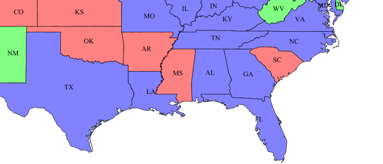
If you look at the labels for Louisiana (LA) and Florida (FL) you will see that
in both cases the label is either over the edge or right on the edge of the
state. Obviously it would look much nicer if it wasn’t, so I changed the name of
the function being called in the Geometry section of the SLD to interiorPoint which gave the following map:
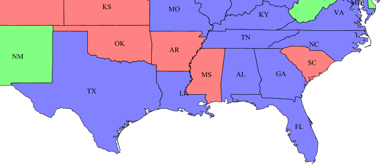
As you can now see, Florida looks better but Louisiana is actually slightly worse, this is one of the cases where we get back a point on the polygon boundary. If we now change the SLD to use the new function:
<TextSymbolizer>
  <Geometry>
    <ogc:Function name="labelPoint">
      <ogc:PropertyName>the_geom</ogc:PropertyName>
      <ogc:Literal>1.0</ogc:Literal>
    </ogc:Function>
  </Geometry>
  <Label>
Note the second argument to the function - this is a tolerance value for the algorithm (but we may remove it and provide a sensible default later). This gives us the following map:

Now Louisiana and Florida look good, with well placed labels.
So please go ahead and test this out on your own data and let the mailing lists know if you find any issues. We are considering making this the default for GeoServer text symbolizers so it would be good to know if there are any issues before we do that. You can grab a SNAPSHOT jar from https://repo.boundlessgeo.com/main/org/geotools/gt-polygon-labeller/16-SNAPSHOT/.